 |
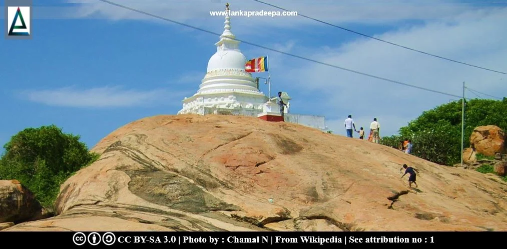
| Figure 1: The modern Stupa built at the present Kirinda Viharaya |
.
Kirinda Raja Maha Viharaya, also known as Kirinda Viharamahadevi Viharaya (Sinhala: කිරින්ද විහාර මහා දේවි රජ මහා විහාරය), is a Buddhist temple on the sea-coast at Kirinda in Hambantota District, Sri Lanka. It is located on the summit of a rocky outcrop situated about 120 m west of the present fisheries harbour of Kirinda.
History
Folklore
It is popularly believed that this temple was built at the spot where Viharamahadevi (Vihara-devi), the mother of King Dutugemunu (161-137 B.C.) and King Saddhatissa (137-119 B.C.) is supposed to have disembarked after she was sacrificed to the sea to appease the gods who were wrath with King Kelani Tissa for unreasonably suspecting and killing of an Arhat (Abeyawardana, 2004; Paranavitana, 2001). The chronicle Mahavamsa records that Vihara-devi landed ashore at Lanka Vihara on the coast near Mahagama [(the landing place is also known as Tolaka Vihara and Kottalata) Nicholas, 1963; Paranavitana, 2001]. King Kavan Tissa (205-161 B.C.) who espoused Vihara-devi constructed the Viharamahadevi Viharaya or Bisovalu Viharaya at this place to commemorate the event (Abeyawardana, 2004; Paranavitana, 2001). However the popular identification of the present Kirinda Viharaya as Viharamahadevi's landing place has no historical authority and the inscriptions found at the site do not bear this popular belief (Nicholas, 1963; Paranavitana, 2001).
Inscriptions
There are two inscriptions in the present temple premises (Somadeva, 2006). Of them, the first one is a metrically composed rock inscription carved on a granite rock surface facing east. The second inscription is engraved on a rock surface situated slightly lower level than the first one (Somadeva, 2006). The first inscription has been dated by scholars such as Nicholas to the reign of King Mahadathika Mahanaga (Somadeva, 2006).
Kirinda rock inscription of Mahadathika Mahanaga
A metrically composed rock inscription was discovered engraved on the vertical face of a large boulder near the ruined Stupa (now restored) of Kirinda Viharaya (Paranavitana, 2001). The record contains four lines and the script closely resembles that of the Maharatmale Rock Inscription (Paranavitana, 2001). From the palaeographical point of view, this inscription has been dated to the reign of King Mahadathika Mahanaga [(9-21 A.D.) Nicholas, 1963].
Script : Later Brahmi
Language: Sinhala Prakrit
Transcript: Siddham. Aparimate lokahi Budha-same nati athana parama......>>
Content: This inscription records that at the Vihara at this spot, the viceroy named Naga abandoned false beliefs and was converted to Buddhism.
References: Nicholas, 1963; Paranavitana, 2001.
An inscription containing similar text to the aforesaid inscription is also found engraved on an octagonal pillar erected on the urban mound at Akurugoda (see: Akurugoda Pillar Inscription) situated approximately 9 km north of Kirinda (Abeyawardana, 2004; Somadeva, 2006). According to the view of scholars, these two inscriptions are unique and bear a political significance (Abeyawardana, 2004; Somadeva, 2006). Nicholas has given a short description about its significance as follows;
"The chronicles give us to understand that from B.C. 246 onwards Buddhism was the firm and only faith of the Sinhalese monarchy and people, and the accuracy of that assertion is not impugned by this solitary instance of one dissident prince professing other beliefs and recanting them in favour of Buddhism. This singular event is not recorded in the Chronicles or Commentaries, but it was apparently of sufficient local importance for the recantation to be publicised by the engraving of two inscriptions, one at the Uvaraja's seat (Mahagama) and the other at the Vihara where the conversion occurred".Citation: Nicholas, 1963. pp.62-63.
.
 |
| Figure 2: The surrounding environment |
.
Attribution
2) This image (Kirinda Pano) has been released into the public domain by its creator, Dennis Sylvester Hurd.
References
1) Abeyawardana, H.A.P., 2004. Heritage of Ruhuna: Major natural, cultural and historic sites. Colombo: The Central Bank of Sri Lanka. ISBN: 955-575-073-4. pp.128,141.
2) Nicholas, C. W., 1963. Historical topography of ancient and medieval Ceylon. Journal of the Ceylon Branch of the Royal Asiatic Society, New Series (Vol VI). Special Number: Colombo. Royal Asiatic Society (Ceylon Branch). pp.62-63.
3) Paranavitana, S., 2001 (Edited by Dias, M.). Inscriptions of Ceylon: Vol. II. Part II. Archaeological Survey Department, Sri Lanka. pp.214-217.
4) Somadeva, R., 2006. Urban origins in southern Sri Lanka. Doctoral thesis in archaeology at Uppsala University. pp.144,311.
Location Map
This page was last updated on 11 November 2023

