|
Udugampola Ancient Pond |
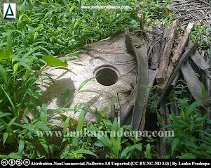
Udugampola Ancient Pond, also known as Udugampola Pathaha/ Pokuna (Sinhala: උඩුගම්පල පැරණි පොකුණ/පතහ), is an ancient bathing pond located in Udugampola in Gampaha District, Sri Lanka. The site can be reached by walking about 450 m along the jogging track which starts from the Udugampola roundabout or by travelling along the Pokuna road which is on the Udugampola-Divulapitiya road located about 400 m distance from the Udugampola roundabout.
History

According to the available historical and archaeological evidence, Udugampola was an Upa-Rajadhani (a sub-kingdom) that was ruled by deputies under the guidance of the king during the Kotte Period [(1412–1597 A.D.) Wijesuriya, 2015]. Several historical sources such as Rajavaliya and Alakeshwara Yuddhaya (The Battle of Alakeshwara) reveal that King Sakalakala Wallabha (or Sakalakala Wallakabahu), one of the sons of King Vira Parakramabahu VIII (1490-1509 A.D.) had ruled this region (Suraweera, 1997). The others, Dharma Parakramabahu (1508/09–1528 A.D.), the eldest son of Vira Parakramabahu VIII became the king of Kotte and Prince Thaniya Wallabha reigned the principality of Madampe (see article: Thaniwella Devalaya). The palace of the king of Udugampola was built at the premises today known as Maliga-godella (the mound of the palace) where the Uththararama Viharaya is situated. Remains of the royal pond and its protective moat are still being identified at the site (Wijesuriya, 2015). Also, the names of several villages surrounding the Udugampola, bear similar pronunciations of various tasks and services attached to the royal palace (Wijesuriya, 2015).
Folklore
According to folklore, two sons of King Sakalakala Wallabha had tried to kill their father by setting up pointed wooden sticks under this bathing pond (Wijesuriya, 2015). However, the king saved his life. A pointed wood fragment which is said to be found during the conservation work of the pond has been placed today in the premises of Udugampola Pradeshiya Sabha.
The Pond

This royal pond is considered an excellent construction belonging to the Udugampola principality and is believed to be the largest pond used by a Sri Lankan king (Wijesuriya, 2015). It has been built in the shape of the English letter "L" extending in an area of about 25,805 sq. meters. The walls of the pond are made of laterite blocks of various sizes. The blocks are nicely fitted with short juts protruding outwards from the bottom to the top. The bunds around the east and south banks of the pond are made of systematically fitted laterite blocks. However, the portion of the bank extending about 122 meters to the north-south direction has not been built with laterites. The water for the pond had been brought from the nearby Aswana Oya through an underground canal (Wijesuriya, 2015).
A Protected Site
The pond known as Pathaha and the remains of its protective moat near Uththararama Purana Viharaya, situated in Udugampola village in the Grama Niladari Division of Pahala Udugampola (North) in Divisional Secretary’s Division of Minuwangoda are archaeological protected monuments, declared by a government gazette notification published on 8 July 2005.


Related Posts
Read Also
References
Books, Government Gazette Notifications, Journal Articles
1) Suraweera, A. V., 1997. Rajavaliya: A critical edition with an introduction (In Sinhala). Educational Publications Department. pp.91-92.
2) The Gazette of the Democratic Socialist Republic of Sri Lanka. No: 1401. 8 July 2005.
3) The information board at the site by the Department of Archaeology.
4) Wijesuriya, D., 2015. Administration of Udugampola, sub kingdom: A historical and archaeological legacy. 3rd Biennial Conference of the International Association for Asian Heritage, 27th - 28th December 2015, Centre for Asian Studies, University of Kelaniya & International Association for Asian Heritage (IAAH).
Location Map
Dynamic Google Map
Attribution
To Whom
1) Pathaha Pokuna 1 by L Manju is licensed under CC BY-SA 4.0
2) Udugampola Kingdom by L Manju is licensed under CC BY-SA 4.0

