
|
Nilavarai Well |
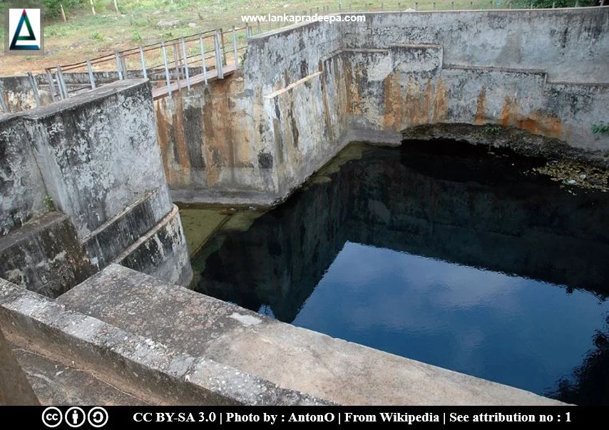
Nilavarai Well (Sinhala: නිලාවරේ ළිඳ හා පුරාවිද්යා නටඹුන්) is an old underground water well located in Navakkiri village in Puttur in Jaffna District, Sri Lanka. This ancient well which has been identified as an archaeological monument is also known by the locals as the Nilawarai Bottomless Well.
The well is famous among the people as a water source that never dries up, not even during severe droughts. Presently, the water of this well is pumped out and used for irrigation purposes.
Formation of the Well
The Jaffna peninsula is mainly underlain by hard, well-dissolvable Lower Miocene Limestone (Mikunthan et al., 2013; Panabokke & Perera, 2005). Although the porosity of the Miocene Limestone is low, some macro-pores, channels and large cavities can be developed in this layer through the dissolving of the limestone (Joshua et al., 2013). The water can accumulate in these pores, channels, and cavities and serve as shallow aquifers. The water from precipitation percolates downwards through the soil and feeds these aquifers and forms mounds or lenses of freshwater floating over the heavy seawater (saline water) that is already present in aquifers (Joshua et al., 2013; Mikunthan et al., 2013; Panabokke & Perera, 2005). When the topsoil layer is collapsed due to some reason such as surface erosion, these limestone caverns are exposed as depressions at the surface like the well at Nilavarai. It is found that the topwater layer of the Nilavarai well contains freshwater and after some depth, the salinity of the water increases towards the bottom of the well.
Archaeological Significance
The existence of a Buddhist Stupa (Great Pagoda) near Nalavarai well is mentioned in the travel records of Rev. Philippus Baldaeus (1632-1671 A.D.), a Dutch minister who was in Jaffna during the Dutch Period of Ceylon (Dias et al., 2016). According to him, there had been ruins of a Stupa near the well and the Portuguese had fought in this place with Sinhalese (Dias et al., 2016).
It remained under the Portugezen sway for upwards of 40 years, wrested from the Emperor by Philippo d' Olivero when he defeated the Cingalezan forces near Achiavelli by the great pagode, where there are still to be seen its ruins and a wonderfully large and wide well, deep and round and its centre 24 fathoms deep, truly a wonderful work hewn out of a huge rock (or, as the inhabitants would have it, split and laid open by thunder)Note 1
Note 1: Apparently the well at Puttoor is being referred to.
Citation: Brohier, 1960. p.316.
Notes: Cingalezan = Sinhalese, Achiavelli = present Achchuveli, a locality near Nilavarai, Pagode = Stupa
The Buddhist temple mentioned by Baldaeus is said to have existed in a village which was called Budgamuwa during the ancient period (Dias et al., 2016). This temple at Budgamuwa had been renovated by King Vijayabahu I (1055-1110 A.D.) who fought with Colas in 1053 (Dias et al., 2016). Paul E. Peiris (1874-1955 A.D.), the District Judge for Jaffna in 1917, also mentions in his notes that in addition to this well, there had been Buddhist ruins in the area (Dias et al., 2016; Wijebandara, 2014).
Nilavarai Buddha Statue

A broken limestone statue of Buddha (only the portion from the waist above) was discovered by a cultivator about 250 yards (228.6 m) west of the Nilawarai well (Schroeder, 1990). The remaining portion of the statue is 3 ft. 3.5 inches high while the head part is about 1 ft. 2 inches in length. The nose had been partly damaged at the time of its discovery. The preserved portion indicates that the Mudra (gesture) of the original statue was Abhaya. Thought to date from the Anuradhapura Period, the statue has a low Ushnisha and a robe designed with a double-line pattern (Haramoto et al., 2015). Fragments of other portions together with some potsherds were also found buried about 2-4 feet deep in the earth. This statue was transferred to the Archaeological Museum of Jaffna (Inv. No. 54-630-23) by the Archaeological Commissioner (9 December 1952).
Besides the statue, the remains of a Stupa which is believed to belong to the 10th century A.D. were discovered near the place where the statue of Nilavarai Buddha was found. It is made of coral stones and brick (Haramoto et al., 2015). Remains of a rectangular building were also identified at the same site.
Folklore
According to Hindu mythology which is usually based on their traditional mystic emotions and religious literary works, the history of this place is related to Rama, a mythical figure mentioned in the Indian epic Ramayanaya. Local people believe that this well was created by Rama when he stroked his arrow into the earth to provide water to refresh his men (Raghavan, 1971). However, the authenticity of the Ramayanaya is controversial and hence it is today dismissed as a myth by Sri Lankan scholars (JRASSL, 2014)
Another folklore says that there was an old Hindu shrine with an underground cave where saints meditated (Raghavan, 1971). It is also believed that the well at Nilavarai has an underground connection with the Springs of Keerimalai, a freshwater pool located about 11 km away from the Nilavarai well (Raghavan, 1971).
The Bottom of the Well
Local people identify this well as a bottomless well. However, the depth of the well was figured in 1895, by H. F. Tomalin by conducting some pumping and plumbing operations at the site. From these operations, he figured the depth of this well as 145 feet (44.196 m) on the northern side, 120 feet (36.576 m) on the south side and 121 feet (36.88 m) on the western side (Raghavan, 1971). S. Arumugam, a Sri Lankan irrigation engineer in his book published in 1969 mentioned the depth of this well as 164 feet 6 inches [(51.81 m) Arumugam, 1969].
On 15 August 2013, the Central Cultural Fund with a group of marine archaeologists carried out an expedition to the Nilavarai well to find the bottom of the well (Dias et al., 2016; Wijebandara, 2014). During this expedition, they successfully discovered the bottom of the well and concluded it by recording the maximum depth of the well as 50 m [(164.04 feet) Dias et al., 2016; Wijebandara, 2014].
The Sri Lanka Navy, who also conducted an expedition at the site with an automated robot found the bottom of this well at a depth of 52.5 m (172.24 feet). During this expedition, several tunnels that are located at different levels and lead toward different directions were observed by them. They further found out that the first 18.3 m of the well contains freshwater and after that point, the salinity of the water increases with the depth. Debris of three carts fallen into the well was also recorded during this expedition.
A Protected Site
The Nilawarai Pond situated in the Grama Niladhari Division of Nawakkiri bearing No. J-275 in the Divisional Secretariat Division of Kopai is an archaeological protected monument, declared by a government gazette notification published on 23 February 2007.

|
Nilavarai Well and Archaeological Ruins |
Related Posts
Read Also
References
Books, Government Gazette Notifications, Journal Articles
1) Arumugam, S., 1969. Water resources of Ceylon: its utilisation and development. Water Resources Board. p.290.
2) Brohier, P., 1960. A true and exact description of the great island of Ceylon by Phillipus Baldaeus: Being the section relating to Ceylon of the "Beschrijving der Oost Indische kusten Malabar en Choromandel der Zelver aangrenzende ryken en het machtige Eyland Ceylon nevens een onstandige en grondigh doorzochte ontdekking en wederlegginge van de afgoderye den Oost-Indische heydenen" by the Revd. Phillipus Baldaeus published in Dutch in Amsterdam, 1672. p.316.
3) Dias, M.; Koralage, S.B.; Asanga, K., 2016. The archaeological heritage of Jaffna Peninsula. Department of Archaeology. Colombo. pp.198-199.
4) Haramoto, T.; Inouchi, C.; Koizumi, Y.; Fukuyama, Y., 2015. Survey Report on the Protection and Utilisation of Cultural Property in the Northern and Northeastern Provinces of Sri Lanka. Japan Consortium for International Cooperation in Cultural Heritage. p.42.
5) Joshua, W.D., Thushyanthy, M. and Nanthagoban, N., 2013. Seasonal variation of water table and groundwater quality of the karst aquifer of the Jaffna Peninsula-Sri Lanka. Journal of the National Science Foundation of Sri Lanka, 41(1). pp.3-12.
6) JRASSL, 2014. Journal of the Royal Asiatic Society of Sri Lanka New Series, Vol. 59, No. 2, Special Issue on the Ramayana (2014). pp.1-112.
7) Mikunthan, T.; Vithanage, M.; Pathmarajah, S.; Arasalingam, S.; Ariyaratne, R.; Manthrithilake, H. 2013. Hydrogeochemical characterization of Jaffna’s aquifer systems in Sri Lanka. Colombo, Sri Lanka: International Water Management Institute (IWMI). pp.3-4.
8) Panabokke, C.R. and Perera, A.P.G.R.L., 2005. Groundwater resources of Sri Lanka. Water Resources Board, Colombo, Sri Lanka, p.3.
9) Raghavan, M.D., 1971. Tamil culture in Ceylon. Kalai Nilayam. pp.40-41.
10) Schroeder, U.V., 1990. Buddhist Sculptures of Sri Lanka. Visual Dharma Publications Ltd., Hong Kong, 1992. p.685.
11) The Gazette of the Democratic Socialist Republic of Sri Lanka. No: 1486. 23 February 2007. p.129.
12) Wijebandara, I.D.M., 2014. Yapanaye Aithihasika Urumaya (In Sinhala). Published by the editor. ISBN-978-955-9159-95-7. pp.118-120.
Location Map
Dynamic Google Map
Attribution
To Whom
1) Nilavarai, Jaffna by AntanO is licensed under CC BY SA 3.0
2) M 9 by Kanatonian is licensed under CC BY SA 3.0
