
|
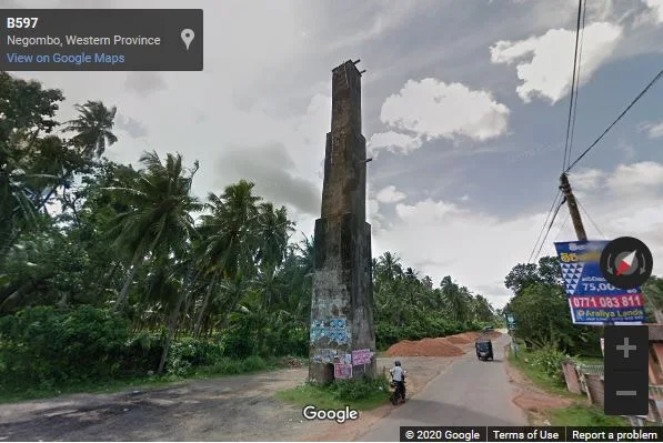
This image was captured by Google Street View (Image capture: Oct 2015) one month before the tower collapsed. It clearly shows the road development process that was carried out near the monument. |
Kandawala Survey Tower (Sinhala: කඳවල මිනුම් කුළුණ) was an old colonial-era tower located at Kandawala junction on the Negombo-Giriulla-Baseline road in Negombo, Gampaha District, Sri Lanka. The tower was considered the oldest survey tower in the country (Dias et al., 2016).
History
The British established the Department of Survey of Sri Lanka (or the Department of the Surveyor General), the oldest unchanged government department in the country, on 2 August 1800 (Vithana, 2006). Under the Surveyor General W. D. Gosset (1855-1858), the establishment of control for surveys on the island commenced with the base measurements in 1857 for Principal Triangulation and several survey towers were used across the country for this process (Dias et al., 2016).
Built in 1766, this Dutch tower in Kandawala, Negombo, was marked as a single trigonometric point when Sri Lanka was first surveyed and the one-inch map was created.
Destroyed Protected Monument
The tower situated in the Grama Niladhari Division of Kadirana, in the Divisional Secretary’s Division of Katana, was declared a protected monument through a government gazette notification published on 6 February 2009. However, the monument completely collapsed on the ground on 28 November 2015 due to the negligence of relevant government authorities. Presently, the site is reserved by the Department of Archaeology for the construction of a replica of the tower.
Related Posts
Read Also
References
Books, Government Gazette Notifications, Journal Articles
1) Dias, M.; Koralage, S.B.; Asanga, K., 2016. The archaeological heritage of Jaffna peninsula. Department of Archaeology. Colombo. p.226.
2) The Gazette of the Democratic Socialist Republic of Sri Lanka. No: 1588. 6 February 2009. p.182.
3) Vithana, P. K., 2006. Surveying and mapping in Sri Lanka. Seventeenth United Nations Regional Cartographic Conference for Asia and the Pacific Bangkok. pp.1-9.
