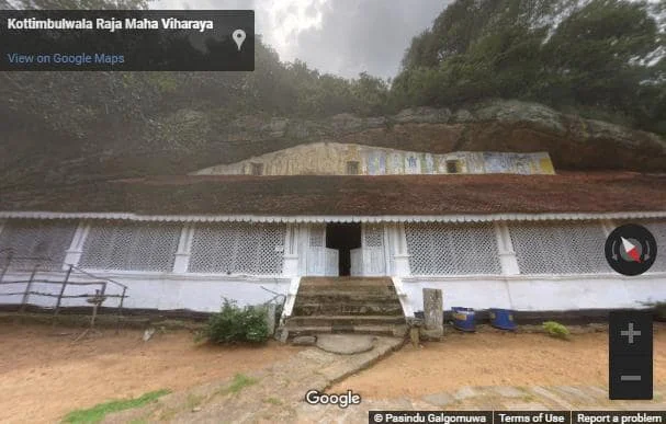
Photo credit: Pasindu Galgomuwa, Google street view
Kottimbulwala Raja Maha Viharaya is a Buddhist temple situated in Ratnapura District, Sri Lanka.
History
Locals link the history of this temple to King Valagamba [(103, 89-77 B.C.) Gnanawimala Thera, 1967]. It is believed that the caves of this place had been used by the king after he was overthrown by a rebellion followed by an invasion from South India. However, he regained the throne by defeating the invaders fourteen years later.
The oldest Stupa of this temple is said to have been constructed by King Buwanekabahu I of Dambadeniya [(1272-1284 A.D.) Gnanawimala Thera, 1967]. It is also believed that King Parakramabahu VI of Kotte (1412-1467 A.D.) is responsible for some of the constructions (Abeyawardana, 2002).
Aramanapola copper plate grant
A copper plate grant of King Sri Vikrama Rajasinghe (1798-1815 A.D.) reveals some historic information about this temple. According to it, Anomadassi Thera who was a monk of the lineage of Kottimbulawala Viharaya restored the old Stupa of the temple by constructing a new rampart. Expending 1285 amount of silvers he also erected a Stupa and three images at Aramanapola Viharaya and the merit thus acquired was offered to the Mahawasala of Kandy (Gnanawimala Thera, 1967). By hearing this meritorious deed, King Sri Vikrama Rajasinghe issued a copper plate in 1730 of Saka years (1808 A.D.), declaring several grants of properties to both Kottimbulwala Viharaya and Aramanapola Viharaya (Gnanawimala Thera, 1967).
Cave temple
The cave temple of Kottimbilawala Viharaya is 120 ft. long and 25 ft. wide (Abeyawardana, 2002). Sculptures and paintings of the Buddhist tradition are found inside the cave.
A protected site
The old hermitage in the premises of the cavern Rajamaha
Viharaya in Kottimbulwala belonging to the Kottimbulwala
Grama Niladhari Division in the Waligepola Divisional
Secretary’s Division is an archaeological protected monument, declared by a government notification published on 30 December 2011.

Photo credit: Pasindu Galgomuwa, Google street view
References
1) Abeyawardana, H.A.P., 2002. Heritage of Sabaragamuwa: Major natural, cultural and historic sites. Sabaragamuwa Development Bank and The Central Bank of Sri Lanka. ISBN: 955-575-077-7. pp.29-30.
2) Gnanawimala Thera, K., 1967. Saparagamu Darshana (In Sinhala). S. Godage Saha Sahodarayo. pp.216-220.
3) The Gazette of the Democratic Socialist Republic of Sri Lanka. No: 1739. 30 December 2011. p.1090.
Location Map
This page was last updated on 27 February 2022
For a complete tourist map follow this link: Lankapradeepa Tourist Map
For a complete tourist map follow this link: Lankapradeepa Tourist Map

