Photo credit: Google Street View
Menik Raja Maha Viharaya, also known as Menik Vehera (Sinhala: මැණික් රජ මහා විහාරය) is a Buddhist temple situated in Debarawewa in Hambantota District, Sri Lanka.
History
The ancient name of Menik Viharaya is not known (Nicholas, 1963). A few inscriptions discovered from this site reveal the historical continuity of the ancient monastery through the ages (Paranavitana, 2001; Somadeva, 2006). A fragmentary slab inscription of the 2nd century A.D. and a 7-8th century A.D. octagonal pillar inscription have been found on the temple premises (Nicholas, 1963; Somadeva, 2006).
Restoration of the ruined temple
In 1882, the land of this ruined temple was handed over to a Buddhist monk named Angella Sri Jinaratana Thera by the then British Governor James Robert Longden [(1877-1883 A.D.) Abeyawardana, 2004]. The restoration work of the Stupa was carried out under the direction of this monk.
Monuments
The large brick-Stupa is the central monument of the temple. According to the view of many, this has been built by Mahanaga, the Prince of Ruhuna in the 3rd century B.C. (Abeyawardana, 2004). However, some have attributed it to King Dutugemunu [(161-137 B.C.) Abeyawardana, 2004]. The ruined Stupa was restored in 1894 keeping to its original shape (Abeyawardana, 2004).
Etha Bendi Gala
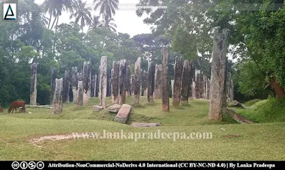
There is a large stone pillar named Etha Bendi Gala which means the pillar where the elephant was tied. According to local tradition, King Dutugemunu has used this pillar to tether his famous elephant Kadol (Abeyawardana, 2004). The pillar contains some traces of an inscription, however, it has not been read yet.
A protected site
The ancient and ruined structures situated in Menik Raja Maha Vihara premises in Debarawewa village in Tissamaharama Divisional Secretariat Division are archaeological protected monuments, declared by a government gazette notification published on 1 November 1996.
References
1) Abeyawardana, H.A.P., 2004. Heritage of Ruhuna: Major natural, cultural and historic sites. Colombo: The Central Bank of Sri Lanka. ISBN: 955-575-073-4. p.97.
2) Nicholas, C. W., 1963. Historical topography of ancient and medieval Ceylon. Journal of the Ceylon Branch of the Royal Asiatic Society, New Series (Vol VI). Special Number: Colombo. Royal Asiatic Society (Ceylon Branch). p.61.
3) Paranavitana, S., 2001 (Edited by Dias, M.). Inscriptions of Ceylon: Vol. II. Part II. Archaeological Survey Department, Sri Lanka. p.268.
4) Somadeva, R., 2006. Urban origins in southern Sri Lanka. Doctoral thesis in Archaeology at Uppsala University. pp.131,427.
5) The Gazette of the Democratic Socialist Republic of Sri Lanka. No: 948. 1 November 1996.
Location Map
This page was last updated on 15 January 2023


