
|
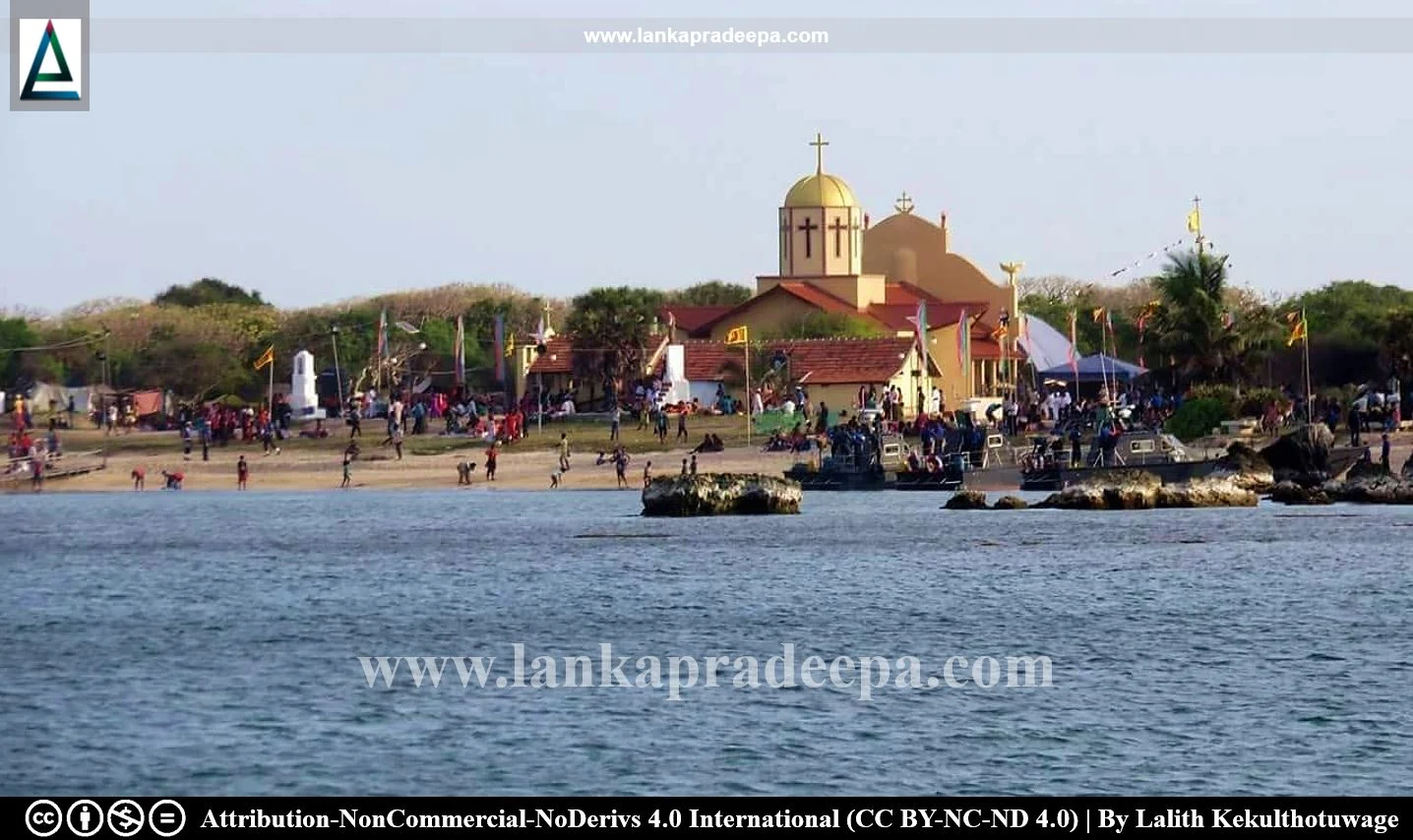
Kachchativu Island Church |
Kachchativu Island is an islet that lies about 15 miles northeast of Rameshwaram and approximately 14 miles southwest of Delft Island within the territorial waters of Sri Lanka. Located in Palk Strait, the island is one mile long, 300 yards broad and extends into an area of 285.2 acres (Raju, 2009). There are no permanent inhabitants or any permanent structures on the island other than a Roman Catholic Church, administered by the bishop of Jaffna (De Silva, 2008). The total control of the island is presently under the Sri Lankan Navy.
History
The oldest name of the island, Kacci (modern Kaccativu) is found in the Rameswaram Inscription of King Nissankamalla (1187-1196 A.D.), along with other nearby islands including Puvagu (modern Pungudutivu), Mininak (Maninaga) and Kara [(modern Karaitivu) Ranawella, 2007]. It mentions that Nissankamalla visited these islands during his expeditions within the realm (Paranavitana, 1970; Ranawella, 2007). Also, more historical evidence indicates that Kachchativu Island has been under the jurisdiction of Sri Lanka since the era of the Portuguese, Dutch, and British (De Silva, 2008; Mayilvaganan, 2019). It had been occasionally used by the British since 1920 as a naval gunnery practice range (Muni, 1974; Raju, 2009).
However, some Indian sources claim that the island was an integral part of the Zamindari of the Raja of Ramnad [(Ramanathapuram of Tamil Nadu: 1601–1949 A.D.) Mayilvaganan, 2019]. This Raja is said to have held a prominent position as the regional landlord under British Colonial rule, with the authority to collect all taxes on his lands and subsequently deliver the collected taxes to the British rulers (Mayilvaganan, 2019).
The Indio-Sri Lanka Maritime Boundary and Kachchativu Island
The maritime boundary separating Sri Lanka and India runs across three distinct sea regions: the Bay of Bengal to the north, the Palk Straits in the central area, and the Gulf of Mannar to the south. The average distance between Sri Lanka and India across the Palk Straits is approximately 32 kilometres (De Silva, 2008).
In the 1921 report on maritime boundary prepared by the British authorities who ruled both India and Sri Lanka at the time, the Island of Kachchativu had been left to Sri Lanka's jurisdiction but India was not agreeable to its proposals (De Silva, 2008). After India and Sri Lanka gained independence, both countries signed two bilateral agreements on the Boundary in Historic Waters in June 1974 and on the maritime boundary in the Gulf of Mannar and the Bay of Bengal in March 1976 (Raju, 2009). Of the two, the agreement in 1974 ensured the sovereign rights of Sri Lanka over Kachchativu Island but allowed Indian fishermen and pilgrims to enjoy their traditional rights on the island (Raju, 2009). However, the 1976 agreement prohibited fishing vessels and fishermen of one country from entering the waters of the other and it placed restrictions on Indian fishermen from entering the sea around the Kachchativu Island (Raju, 2009). On 15th January 1977, the Sri Lankan government formally declared Sri Lanka's side of the maritime boundary indicating Katchchativu Island as a part of Sri Lanka (De Silva, 2008).
Sri Lanka Civil War and Tamil Nadu Politics
The escalation of the civil war in Sri Lanka in 1983 significantly complicated the India-Sri Lanka arrangement regarding Kachchativu Island (Mayilvaganan, 2019). This was exacerbated by the gradual increase in attacks on Indian fishermen by the Sri Lankan Navy in the vicinity of Kachchativu, especially since the beginning of Eelam War IV in 2006 (Mayilvaganan, 2019). It resulted in several debates on the ownership of the island mainly because of Tamil Nadu politicians who desire to extend their fishing area (De Silva, 2008). In 2008, a case was filed by the Opposition Leader of Tamil Nadu, Ms. Jayalalitha Jayaram, before the Indian Supreme Court, seeking reconsideration of ownership of Kachchativu (De Silva, 2008; Mayilvaganan, 2019). It is evident that throughout history, such claims have been orchestrated by Tamil Nadu politicians, particularly before election campaigns (De Silva, 2008).
St. Anthony's Church
The cultural importance of Kachchativu Island lies in St. Anthony's Church where pilgrims from both countries gather every year in March-April for a week-long religious festival (Muni, 1974). This catholic church is said to have been established by Indian fishermen (Raju, 2009).
Related Posts
Read Also
References
Books, Journal Articles
1) De Silva, S., 2008. Sharing Maritime Boundary with India Sri Lankan Experience. Faculty of Defence & Strategic Studies. General Sir John Kotelawala Defence University. pp.3-4,7-9.
2) Mayilvaganan, M., 2019. ‘Trouble waters’: Maritime issues in Palk Strait, Indian Ocean. Samudera-Journal of Maritime and Coastal Studies, 1(1), pp.35-48.
3) Muni, S.D., 1974. Kachchativu settlement: Befriending neighbouring regimes. Economic and Political Weekly, pp.1119-1122.
4) Paranavitana, S., 1970. Ramesvaram inscription of Nissankamalla. Epigraphia Indica. Vol. XXXVI. pp.23-32.
5) Raju, A.S., 2009. The (in) security of fishermen in South Asia. Fisheries exploitation in the Indian Ocean: Threats and opportunities, pp.163-174.
6) Ranawella, S., 2007. Inscription of Ceylon. Volume VI. Department of Archaeology. ISBN: 978-955-91-59-61-2. pp.117-125.
Location Map
Dynamic Google Map
Attribution
To Whom
LankaPradeepa.com extends its gratitude to Lalith Kekulthotuwage for providing the necessary photographs required for this article.
