
|
Kotmale Reservoir |
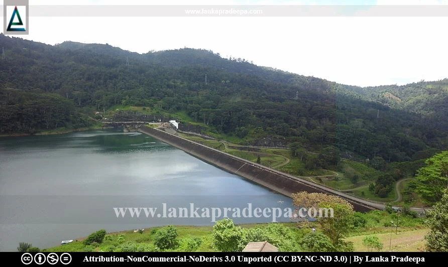
Kotmale Reservoir, also known as Gamini Dissanayaka Reservoir (Sinhala: කොත්මලේ ජලාශය; Tamil: கொத்மலை அணை), is a hydroelectric and irrigation reservoir located in Kotmale, Nuwara Eliya District, Sri Lanka. Situated 703 m above mean sea level, it is the deepest upstream hydroelectric reservoir in the country (Silva, 1996).
History
Kotmale project is one of five major projects that was undertaken under the Mahaweli Development Scheme (Manatunge & Takesada, 2013). It is also the uppermost reservoir in the reservoir network constructed under that scheme (Abeysinghe, 2005).
The plan for the construction of Kotmale Dam was initially proposed in 1961, for the purpose of hydroelectric power generation and irrigation water supply (Takesada et al., 2008). A full feasibility study was conducted from 1973 to 1976 by the Water Power Development Consultancy Services of India (Johansson, 1989).
The construction work of the dam was started in September 1979 and the water filling of the reservoir commenced in November 1984 (Johansson, 1989). The reservoir flooded nearly 4,000 ha of land in the Mahaweli upper catchment and about 3,056 families were resettled due to inundation (Manatunge & Takesada, 2013). The dam was commissioned in 1985 (Takesada et al., 2008). The Government of Sweden financially assisted the whole project (Dissanayake, 2016; Manatunge & Takesada, 2013).
On 11 April 2003, the reservoir was named Gamini Dissanayaka Reservoir.
Reservoir

The reservoir has been created by making a rock-fill dam between Kadadora and Thispane mountains blocking the Kotmale Oya. The dam is 600 m long and 87 m tall. Apart from the Kotmale Oya, Poona Oya, Pundalu Oya, Makandura Oya and the Gerandi Ella are the major inflows of the Kotmale Reservoir (Abeysinghe, 2005; Silva, 1996). The reservoir generates 201 megawatts of power (by three 67 MW turbines) at its hydroelectric power station located at Atabage (Abeyawardana, 2004; Takesada et al., 2008).
The water impounded by the reservoir is conducted through a 7 km long headrace tunnel, down a steeply inclined high-pressure shaft and onto the underground power station at Atabage, the first of its kind in the country (Johansson, 1989). After power generation, the water is discharged through a 645 m-long tailrace tunnel to the outfall in the Mahaweli Ganga at the Atabage Oya confluence (Johansson, 1989).
An information centre has been established near the reservoir for the benefit of visitors to the site.
General & Morphometric Characteristics
-
#) Catchment area: 563 sq. km
#) Inflowing rivers (major): Pundalu Oya, Puna Oya and Kotmale Oya
#) Outflowing river: Mahaweli Ganga
#) Surface area: 6.5 sq. km
-
#) Maximum breadth: 1.41 km
#) Maximum depth: 90 m
#) Mean depth: 26.8 m
#) Shoreline: 45 km
#) Maximum length: 6.8 km


Related Posts
Read Also
References
Books, Journal Articles
1) Abeysinghe, K.G.A.M.C.S., Nandalal, L.K. and Piyasiri, S., 2005. Prediction of thermal stratification of the Kotmale reservoir using a hydrodynamic model. Journal of the National Science Foundation of Sri Lanka, 33(1). pp.25-36.
2) Abeyawardana, H.A.P., 2004. Heritage of Kandurata: Major natural, cultural and historic sites. Colombo: The Central Bank of Sri Lanka. p.243.
3) Dissanayake, N.K.M., 2016. Evaluating new towns in the context of mega projects: a case study of the Mahaweli Architectural Unit, Sri Lanka (1983-1989) (Doctoral dissertation). pp.25-26.
4) Johansson, D., 1989. The Kotmale Environment: A study of the environmental impact of the Kotmale Hydropower Project in Sri Lanka. SIDA Evaluation Report, Infrastructure, Sri Lanka. ISBN: 91-586-7102-1. pp.7
5) Manatunge, J. and Takesada, N., 2013. Long-term perceptions of project-affected persons: A case study of the Kotmale Dam in Sri Lanka. International Journal of Water Resources Development, 29(1), pp.87-100.
6) Silva, E.I.L., 1996. Water Quality of Sri Lanka. Institute of Fundamental Studies, Sri Lanka. pp.83-91.
7) Takesada, N., Manatunge, J. and Herath, I.L., 2008. Resettler choices and long‐term consequences of involuntary resettlement caused by construction of Kotmale Dam in Sri Lanka. Lakes & Reservoirs: Research & Management, 13(3), pp.245-254.
