Parakrama Samudraya (lit: Sea of Parakrama) (Sinhala: පරාක්රම සමුද්රය; Tamil: பராக்கிரம சமுத்திரம்) is a large man-made irrigation reservoir located near the Ancient City of Polonnaruwa, Sri Lanka.
History
Parakrama Samudraya is said to have been created by connecting three original reservoirs, viz: Topa Wewa, Eramudu Wewa, and Dumbutulu Wewa (Schiemer, 2012). Topa Wewa is the northernmost reservoir and it is considered the oldest construction of the three reservoirs (Schiemer, 2012).
Chronicles mention that Topa Wewa was constructed during the reign of King Upatissa I [(365-406 A.D.) Nicholas, 1963].
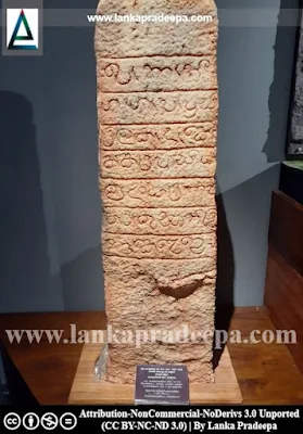
The middle part of the Parakrama Samudra is the Eramudu Wewa while the southernmost part is the Dumbutulu Wewa. These two parts were constructed during the reign of King Parakramabahu I [(1153-1186 A.D.) Schiemer, 1981]. The Parakrama Samudra Pillar Inscription (12th century) that was discovered on the bund of this reservoir reveals that the Parakrama Samudra was constructed by King Parakramabahu I for the benefit of the whole world (Ranawella, 2007).
The dam of the middle part of the Parakrama Samudra was destroyed in 1854 and the area was subsequently swallowed by the forest (Schiemer, 1981). It was reconstructed by 1945 (Schiemer, 1981).
The reservoir
This shallow reservoir (Z max= 12.7 m) which is extending into an area of about 25.5 km2 is considered one of the larger reservoirs of an ancient irrigation system (Schiemer, 2012). It has a natural catchment area of about 75 km2 located on the western side of the lake (Schiemer, 2012). The same side is bordered by the Sudukanda Ridge (Schiemer, 2012). The reservoir is mainly fed by a channel from the Amban Ganga River and the inflow is regulated by the Anicut at Angamedilla (Arumugam, 1969; Schiemer, 2012).
- Reservoir data
Length of bund: 12.38 km
Bund height (Max.): 9.45 m
Catchment area: 71.71 km2
Area at f.s.l.: 2539.50 Ha.
Capacity at f.s.l.: 134.07x10⁶ m3
Dead storage: 18.45x10⁶ m3
- Sluice & spill data
No of sluices: Three - (I), (II), (III)
Sill level: [(I) 51.51 m, (II) 51.82 m, (III) 51.82 M.S.L.]
Max discharge: (I) 13.02 m3/s, (II) 4.53 m3/s, (III) 1.41 m3/s.
Spills: Natural (N) and Radial gates (RG)
Sill level: (N) 59.30 m, (RG) 59.15 m
Length: (N) 121.96 m, (RG) 30.48 m
.
References
1) Arumugam, S., 1969. Water resources of Ceylon: its utilisation and development. Water Resources Board. pp.246-247.2) Nicholas, C. W., 1963. Historical topography of ancient and medieval
Ceylon. Journal of the Ceylon Branch of the Royal Asiatic Society, New
Series (Vol VI). Special Number: Colombo. Royal Asiatic Society (Ceylon
Branch). pp.174,185.
3) Ranawella, S., 2007. Inscription of Ceylon. Volume VI. Department of Archaeology. ISBN: 978-955-91-59-61-2. p.47.
4) Schiemer, F., 1981. Parakrama Samudra
(Sri Lanka) Project, a study of a tropical lake ecosystem I. An interim
review: With 3 figures and 1 table in the text. Internationale Vereinigung für theoretische und angewandte Limnologie: Verhandlungen, 21(2), pp.987-993.
5) Schiemer, F., 2012. Limnology of Parakrama Samudra—Sri Lanka: A case study of an ancient man-made lake in the tropics (Vol. 12). Springer Science & Business Media. pp.1,4-5.
Location Map
This page was last updated on 8 April 2023


