
|
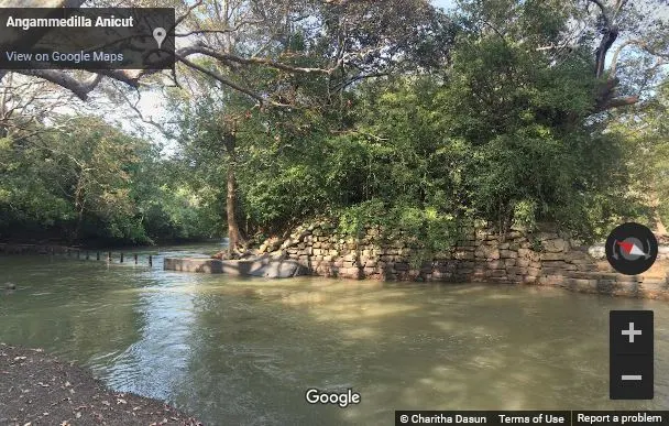
Angammedilla Anicut (Google Street View) |
Angamedilla Gal Amuna (Sinhala: අංගමැඩිල්ල ගල් අමුණ) is an ancient anicut (presently a dam) that lies on the edge of the Angamedilla National Park in Polonnaruwa District, Sri Lanka.
History
The anicut and its conveyance channel were constructed by King Parakramabahu I (1153-1186 A.D.) to bring the waters of the Amban Ganga river (ancient Kara Ganga) to Parakrama Samudraya, a great reservoir built by Parakramabahu by connecting three original reservoirs, viz: Topa Wewa, Eramudu Wewa, and Dumbutulu Wewa (Arumugam, 1969; Nicholas, 1963). The channel was originally known as Akasa Ganga but is presently called the Angamedilla Yodha Ela (Arumugam, 1969; Nicholas, 1963).
The Modern Dam
A new dam was constructed later on the same spot on which the ancient anicut stood (Wikramagamage, 2004). As a result of that, the original anicut is no more visible, but a part of the protective wall along the right bank built with massive blocks of stone still can be identified. The present dam is 90 ft. long and 45 ft. high and was restored during the period between 1948-1952 (Arumugam, 1969; Wikramagamage, 2004).
Angamedilla Yodha Ela
The entire length of the Angamedilla Yodha Ela is 3 miles and 42 chains (Arumugam, 1969; Wikramagamage, 2004). The bed width of the channel is 40-50 ft. and has a depth of 6 ft. (Arumugam, 1969; Wikramagamage, 2004).
Related Posts
Read Also
References
Books, Journal Articles
1) Arumugam, S., 1969. Water resources of Ceylon: its utilisation and development. Water Resources Board. pp.246-247.
2) Nicholas, C. W., 1963. Historical topography of ancient and medieval Ceylon. Journal of the Ceylon Branch of the Royal Asiatic Society, New Series (Vol VI). Special Number: Colombo. Royal Asiatic Society (Ceylon Branch). pp.183,185.
3) Wikramagamage, C., 2004. Heritage of Rajarata: Major natural, cultural, and historic sites. Colombo. Central Bank of Sri Lanka. p.269.
